Saturday - we are off the dock by 8:15 from Port Charles Marina.
 This is the cut between the two islands that we should have taken to come into the marina. I'm not sure why the water looks so blue in this picture, I can assure you it wasn't.
 We went through Mel Price Lock and Dam on the Mississippi. Our visitors have never seen a lock so they were impressed by its size.
The first of several, on the water, dry docks for the massive river tugs. We saw some of these dry docks in Baltimore for the Navy ships. Incredible the amount of tonnage these can lift.
 Coming into St. Louis, this is one of two 400 ft bridge structures for the new Mississippi River Bridge. The bridge will connect downtown St. Louis and southwestern Illinois. Poplar Street Bridge currently carries three interstates including I-70. This project will relocate I-70 traffic from the Poplar Street Bridge to the new Mississippi River Bridge. It should open for traffic in 2014.
 Bridges across the Mississippi with the arch in the background.
Fun pictures of all of us under the arch!!


 Some bluffs on the Mississippi River. The house on the bluff was cool looking. What a view!
 Taylor at the helm. Papa instructing. She did pretty good on this big curvy river. We traveled 63 miles today. Had a wonderful time including the kids in this part of our journey.
  Arriving at Hoppies. This marina is right on the river. It's been around for about 70 years. Fern and Hoppie run the place with their daughter. The current is about 3mph so I had to go past and come back up river to dock in between two other boats. It's hard to imagine how this place has survived. It is just barges rafted together anchored to land with cables. Pretty crude arrangement but a welcome site knowing there isn't anyplace to stop for another 40 miles.
Fern gathers all the crews and provides local knowledge of the Mississippi. She gave us anchorages to try as well as places to avoid. Told us what to watch for, like specific mile markers where the curve of the river along with the weir dikes makes for narrow, rapid water. Other boaters report back to her with water depths since the water is lower than it has been in the past so the information is relatively current. These "Fern" talks are legendary.
We opted for dinner in tonight. Jeremy, the grill master, did a superb job. What a great weekend!
Sunday - Had breakfast in. The kids left about 10am. We took off shortly after. A couple of other boats left earlier heading for Kaskaskia Lock, a 40 mile run with the option of spending the night on the lock wall. This isn't a lock we transit but was a wonderful option since the next anchorages were iffy and no marinas. And we knew our next day would be a long one, over 100 miles.
 Just wanted to give a perspective of how crude Hoppies is. Only as wide as a single barge with junk strewn all over.
  That's Wind Song to the left.
  This is the gathering place for the "Fern" talks. She is a heavy smoker so the obvious need for the ashtray.
  Here we are at the Kaskaskia Lock wall. Tuff eNuff (sailboat) is rafted to Murial June. I believe they did this so there would be room for us as well. Nice. Several work boats were tied to the wall in front of Muriel June so space was at a premium. Also, there were no cleats so we had to borrow lines from Muriel June to tie to the railing over 50 ft from the boat. It worked, thanks to their help. They also invited everyone over for docktails this evening. We discussed an early morning departure since it would be a long day.
Monday - 6:03am and we are off in the fog and it is still dark, in my book. I hate it when we do this.
 A picture from the bridge sitting at Kaskaskia Lock. At the speed we travel we knew it would be a long day so wanted to get going early. Discussed our departure time with the crew of other two boats so we could sort of travel together.
 Sunrise was 6:36 but the fog stayed with us until after 7am.


 Oh, did I mention that it was cold. I layered, grabbed my coat and gloves and was still chilled. We opened the windows to watch for floating logs as well as on-coming traffic. We were a couple of hours in before the fog lifted.
 This shows the significant current against the buoy. Based on the GPS speed vs the water speed, we were getting about 3-5 mph help going downstream.
 This tug had what looked like 24 barges (4x6). Most must have been empty.
 Some shoreline along the Mississippi
 This was a narrow spot. We waited while the tow got around the curve.
  Cape Girardeau waterfront.
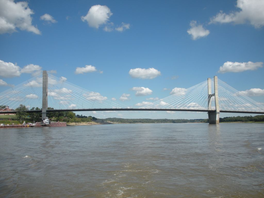 The bridge at Cape Girardeau
 Little Diversion Channel used to be a great anchorage but isn't an option with the low water levels.

 It's about 4:30pm. We've traveled the Mississippi to where it meets the Ohio River. At this point, we make a left turn and cross under the bridge at Cairo, IL. Once we make the turn, our GPS speed drops from about 12.0-7.5mph. Bummer!
 All the activity in the distance is the building of the new Olmsted lock which will replace both lock and dam numbers 52 and 53. And what we find the next day at these two locks, it's long overdue.
Today we traveled 134 miles in 12.5 hours. I believe this was our longest travel day yet other than the Gulf crossing. What a day!
No comments:
Post a Comment