We haven't experienced locks like this and hope we don't again. Big, round concrete pilings with rusted metal around them.
  When Peggy called the lock, she was told that we would be rafting at the lock. They entered and got tied up then we came up beside them and tied to their boat. We understand this was the norm for lots of other loopers.
 Peggy holding the lines at the bow of Muriel June.
 I thought this was interesting. The barge is lifted on rails, kept level, emptied or filled, then lowered back into the water. Similar to the Big Chute in Canada only on a much smaller scale.
 I-24 bridge across the Ohio near lock 52. Called the lock requesting lock through and were told the wait would be about 2 hours.
 Our wait was about 2 hours as expected. We were told to provide lines to the line handlers. They would loop them around the stationary bollard then toss back to the boat. This lock is incredibly busy. Jerry found a US Corp of Engineers website with lock status. We could see how many boats were waiting. Pleasure craft are way down on the list, so we were lucky to get through so quickly.
 A closer look at the lock pilings.
 Once the lock had filled, we were told to get going because a tow was waiting to get through. You can see it on the other side of the lock gate. It happened to be 6 wide so we didn't have a lot of room to get by, from this vantage point.
 Capt. Mema. Have to wear life jackets in the locks even if you're not out on deck.

 That's Muriel June sliding past the barge. Plenty of room.
 Passing Paducah, KY riverfront. A decision point to either continue up the Ohio River and join the Cumberland River or enter the Tennessee River here. The Kentucky Lock is the deciding factor. It is privately run and isn't pleasure craft friendly. Peggy tried to call and they didn't even answer so we went on to the Cumberland. A longer run, another 25 miles but the wait at the lock could be a problem.
  Lots o'rocks
 Jerry is good, he shot this picture of a bald eagle with a fish in it's talons. Too cool!
 Entering the Barkley Lock makes us feel kind of small. This lock is newer so has floating bollards. Also this lock provides a 57 ft lift. The lockmaster isn't very chatty but gets the job done.
 Pulling into Green Turtle Bay marina at about 7:00 pm. Another long day, 76 miles, 10 hours. We are so close to the end of the loop, only 25 more miles.
We are greeted by several fellow loopers. They are going out for dinner. I just want to shower and veg. Our plan here is to rent a car, recover the Expedition from St. Charles and plant it at Kenlake marina where we will spend a month or so once we finish the loop.
Wednesday - Enterprise in Paducah picked us up. I can't say enough good things about what good service we have received from each of the Enterprise offices over the last year. Some have been hesitant to drive 20 miles or so to get us but most have lived up to their motto.
We drove to Port Charles Marina where we had left the Expedition. Picked up the car, had lunch then headed back to Green Turtle Bay. Dinner was planned this evening with two other loopers, Muriel June and the Blue Heron at Patti's in Grand Rivers. We arranged to meet them there. It worked out great, had a wonderful meal and good conversation. I would highly recommend the 2" thick pork chop (but split it).
Thursday - a couple of other looper boats arrived so we had docktails with them in the evening then dinner at the marina restaurant. I think there were 13 for dinner. Great time.


Friday - the big day!!!
We departed Green Turtle Bay about 9am. Back out on the Cumberland for about a mile to the Barkley Canal or "the cut". This mile and a half canal connects Lake Barkley (Cumberland River) with Kentucky Lake (Tennessee River).
 A Coast Guard work boat was replacing buoys in the cut and pulled out in front of us.
 He moved onto Kentucky Lake but stopped to replace another buoy.
 Almost a daily ritual. Our morning snack was celery, carrots and hummus. No reason today should be any different.
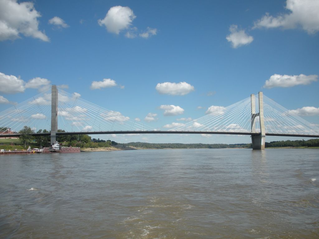
 The Eggners Ferry Bridge, the end of our Great Loop.
 It doesn't count until we go under the bridge.
 And now we can display the AGLCA Gold Burgee replacing the white one. We are happy campers to have completed the loop. Hard to believe it's been just shy of 11 months, 6,217 miles traveled.